Cell Mapper is a crowd sourced resource for the location of cell towers. However, the site does not have all the cell towers and there can be errors, so it is to be used as a tool and not the full story on if a tower is close. You will notice Green (Verified Tower) and Red (Not verified and full of errors) tower markers.
Carrier coverage maps can be helpful, sometimes. AT&T and Verizon love to show the entire U.S. is covered in quality 4G signal, when we all know that isn’t true, however, T-Mobile does a pretty good job. On AT&T/Verizon, if your customer is in a 5G covered area, that will mean, there is a good chance of quality 4G signal. But again, this too can not be used as a 100% proof of good signal.
City-Data – An Index of Antenna Towers registered with the FCC. This listing shows ALL towers, be it radio, tv, or cell towers. You can look in the area you are trying to qualify and find towers in the area. Sometimes the carrier is hidden in the registration or the email address of the registrant.
Antenna Search -You will type in an address and it will give all registered towers within the 2 mile range. The FCC records aren’t always updated with new towers, so a new tower that just was built, may not show up in FCC database searches.
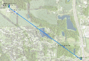
The USGS website is a great tool to be able to search if there is a hill blocking the cell signal. Once you find the tower closest to the customer, you can mark the tower and customer location on the map and see a straight line between the two. You can then spot the elevations of both locations and see if any hills would be an issue. Remember, the tower antenna’s are going to be 75-150 feet above the elevation, so signal will make it over small hills, but if the hill is above the tower it will not be a usable signal. (See our training video on how to use this great tool.)
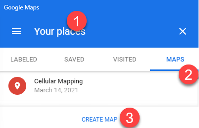
We highly recommend using Google Maps and creating your own signal readings map, which is free and easy. When logged into your Google account, visit Google Maps, in the menu, select “Your Places”. The select the tab of “Maps”. Once there, you can create a map.
You will then be able to log signal tests and if another customer calls in that area, you already have an idea of what works and what doesn’t. In our example to the left, Black icons are Verizon towers and tests that had good Verizon signal.

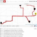
For those that drive around to a number of customer locations to do signal tests, we have found this free website a very useful tool. You can enter in all the locations and it will plot the fastest route to make all those location. You can create a free account and store your settings. They do have a paid account, but it’s for trucking companies that do a tremendous amount of monthly route planning, so the free account should be just fine.